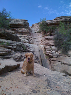
It has been a hot summer here in Grand Junction, but the thermometer didn't get up to triple digits until Wednesday. With the temperatures only in the mid-nineties and the humidity near zero, it has been reasonably comfortable to take long weekend hikes with Scout provided there was some shade and I carried plenty of ice cubes and water in my CamelBak.
This past weekend, Scout and I drove over to the Bangs Canyon area off Little Park Road, just a few miles from home, and hiked about two miles to Rough Canyon Falls, an intermittent waterfall in a pristine sandstone canyon. There are two ways to get to the falls from the Bangs Canyon parking lot, and we had tried the more scenic Rough Canyon route a couple of weekends earlier without success. There had been a fair amount of rain, and the scoured floor of the canyon had held it in muddy pools that required skirting around the edges over some difficult boulders, at least for me. Scout waded and swam through many of the pools, but I didn't want to risk a fall on the slippery bottoms. We finally reached a point where I would need to scramble down a steep pitch using both hands and feet, and I decided we should turn around. Scout might have made it down, but he wouldn't have made it back up.
As we backtracked, I noticed one of those brown fiberglass stake signs. I hadn't seen it earlier because we had been on a different track of the braided trail. It warned against defacing the site, which I took to mean that there was something worth seeing along the short spur leading away from the sign. Sure enough, on a sandstone face beneath a huge overhang, there were some impressive petroglyphs of humanoid characters and a design of circles that reminded me of the map petroglyph in Hidden Valley, south of Moab. Of course, against the wishes of the sign, there was graffiti all around the petroglyphs. I don't understand why people can't just leave well enough alone.
That day, we could have continued back to the trailhead and taken the easier canyon rim route to the falls, but we opted to continue up the canyon past the turnoff to the parking lot and do the Mica Mine hike instead. Nan and I had done it once a few years ago with Charlie and later learned that we had turned around before reaching the actual mine, thinking that the large piles of mica tailings we spotted were the mine's remnants. I wanted to see what we had missed, and we still had plenty of water, so off we went. The trail was really just an old jeep road that the miners had painstakingly forged through the canyon. It was easy hiking and there was plenty of shade. Within a half-hour, we had passed the tailings and reached the actual mine, which is more of a large, excavated cave. There were still plenty of mica extrusions covering the walls, and I wondered if the miners had been trying to extract it in certain-sized plates, because there were fingernail-sized pieces of mica covering the ground all around the mine. I put a piece in my pocket, took photos of Scout, and then hiked out.
The rim route to Rough Canyon Falls, which doubles as a four-wheel drive slickrock road, delivered us to the falls without difficulty this past hot and sunny Sunday. Scout and I got a late start, and there was little shade, so we were happy for a slight breeze and a downhill course. I had hiked to the falls with Scout a couple of years ago because I had heard that there were petroglyphs and moqui steps to be seen, but we had seen only the falls themselves, though we carefully searched the area around the top of the falls, which were not flowing that day. I had mentioned this hike to Kelly, my guitar instructor, and he had said that there were indeed petroglyphs and moqui steps at the falls; we must have missed them somehow.
I tried to remember exactly where Kelly had said the sights were located as we hiked the two miles to the falls, but I couldn't. He had made their location sound so obvious, I figured we would find them easily. Well, I was wrong. The rim route dumps hikers at a spur that takes them to the top of the falls, just like the canyon route does. Scout and I searched that area thoroughly without finding anything noteworthy except for some nice muddy pools for Scout to cool off in. We worked our way down as far as we could, to the place where two old cottonwood trunks are wedged together in the narrow slot of the falls, and figured that if there were going to be any moqui steps, this is where they would be, going up the walls next to the falls. But they weren't there and the falls weren't flowing. We backtracked, looking for a way to get down to the very bottom of the falls, but it was a sheer twenty-foot drop all along the lower rim. There is a way to get down there by continuing along the rim route to where it crosses the creek bed and then hiking up the creek bed to the falls, but that was almost another mile of hiking and we were running low on water.
We slogged back up to the trailhead in the afternoon heat, Scout seeking shade and drinking from my CamelBak. I was thinking that the petroglyphs and moqui steps must be on the lower walls that we couldn't see from that lower rim. Maybe we'll get a cool, early morning start this coming weekend and see if we can't finally find them. I have a guitar lesson on Friday, so I'll try to get more exact directions from Kelly. Third try's the charm!
This blog is an account of the pursuit of a dream, to sail around the world. It is named after the sailboat that will fulfill that dream one day, Whispering Jesse. If you share the dream, please join me and we'll take the journey together.
For Charlie and Scout
For Charlie and Scout
About Me

- John Lichty
- Savannah,
Georgia, USA
"Go confidently in the direction of your dreams. Live the life you have imagined." --Henry David Thoreau
 Raising Charlie: The Lessons of a Perfect Dog by John Lichty
Blog Archive
Followers

Recommended Links
- ATN Sailing Equipment
- ActiveCaptain
- BoatU.S.
- Coconut Grove Sailing Club
- Doyle Sails - Fort Lauderdale
- El Milagro Marina
- John Kretschmer Sailing
- John Vigor's Blog
- Leap Notes
- Noonsite.com
- Notes From Paradise
- Pam Wall, Cruising Consultant
- Practical Sailor
- Project Bluesphere
- Sail Makai
- So Many Beaches
- Windfinder
Thursday, August 25, 2011
Subscribe to:
Post Comments (Atom)


No comments:
Post a Comment