The Colorado National Monument is practically right outside our back door, but we rarely visit because it is a National Park and dogs are not allowed. As conscientious dog owners, we naturally want to go where our dog is welcome. As a result, we have missed many excellent hiking opportunities.
When my friend John Sasso called me on Friday afternoon to ask if I would be interested in hiking Serpents Trail, which is located in the Monument, my first impulse was to say no. It wouldn't be fair to Scout. But I checked with Nan and she said that I should go, that she would take Scout for his afternoon walk in the neighborhood.
John picked me up at around 2:30 and we were at the trailhead off Monument Road less than fifteen minutes later. As we started out, John explained that Serpents Trail was part of the original road that the Monument's earliest advocate, John Otto, had built in the early 1900s to enable transportation from the valley floor to the rim. It was first used as a pack trail for horses and mules but later widened for early automobiles. The "trail" was considerably wider and smoother than I would have guessed it to be, and I could imagine a Model T rumbling slowly up it.
When we reached one of the higher-up hairpin curves, from which the trail undoubtedly gets its name, John pointed out a sloping shelf of sandstone and said it was a shortcut that would reconnect with the trail higher up. I followed him as he walked the steep, narrow shelf, one foot in front of the other, consciously not looking to the left, where the shelf dropped into a deep, dark crack. As John said, "You wouldn't want to fall here."
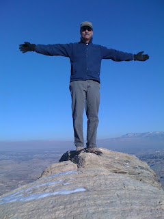
We did indeed reconnect with the trail, and a little ways later, the trail reconnected with the paved road that has replaced it as the motorized way to the rim. The first photo was taken at that intersection and shows that there is a significant elevation gain in the forty or so minutes that it takes to hike up from the trailhead. That's Grand Mesa over my left shoulder, almost obscured by a "brown cloud" of air pollution on an otherwise crystal clear day.
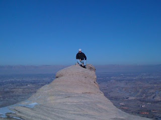
We turned around and retraced our steps, including the dangerous sandstone shortcut. Back on the trail, around another endless curve, John pointed out the way to what he calls "Otto's Nipple," a breast-shaped cone of sandstone a few hundred yards off the trail. We picked our way carefully through the snow and up a short vertical sandstone pitch to get to it. In his photo, John almost looks like he could launch into freefall from the summit tip. I took the more cautious approach and sat for my photo, which shows a sweeping panorama of the Grand Valley, including the city of Grand Junction and the distant Book Cliffs. Click any of the photos for full-size views.
Now that I have had a little taste of what I have been missing by not hiking in the Monument, I will need to figure out a way to get up there more often. John is an avid rock climber, and he has offered to take me up Independence Monument, a difficult sandstone tower first climbed by--you guessed it--John Otto. I can't wait!
Happy Birthday, Nan!
This blog is an account of the pursuit of a dream, to sail around the world. It is named after the sailboat that will fulfill that dream one day, Whispering Jesse. If you share the dream, please join me and we'll take the journey together.
For Charlie and Scout
For Charlie and Scout
About Me

- John Lichty
- Savannah,
Georgia, USA
"Go confidently in the direction of your dreams. Live the life you have imagined." --Henry David Thoreau
 Raising Charlie: The Lessons of a Perfect Dog by John Lichty
Blog Archive
Followers

Recommended Links
- ATN Sailing Equipment
- ActiveCaptain
- BoatU.S.
- Coconut Grove Sailing Club
- Doyle Sails - Fort Lauderdale
- El Milagro Marina
- John Kretschmer Sailing
- John Vigor's Blog
- Leap Notes
- Noonsite.com
- Notes From Paradise
- Pam Wall, Cruising Consultant
- Practical Sailor
- Project Bluesphere
- Sail Makai
- So Many Beaches
- Windfinder
Tuesday, January 11, 2011
Subscribe to:
Post Comments (Atom)


No comments:
Post a Comment