


About Me

- John Lichty
- Savannah,
Georgia, USA
"Go confidently in the direction of your dreams. Live the life you have imagined." --Henry David Thoreau
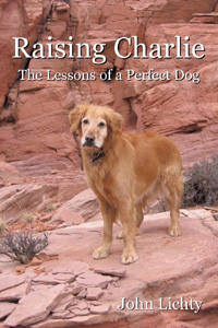 Raising Charlie: The Lessons of a Perfect Dog by John Lichty
Subscribe To

Sunday, October 23, 2011
Google Map of the Trip from Charleston to Savannah
Sunday, October 16, 2011
Check-in/OK message from Whispering Jesse SPOT Messenger - 10/16/2011 12:07:42 EDT
Whispering Jesse
Latitude:31.89
Longitude:-81.06207
GPS location Date/Time:10/16/2011 12:07:42 EDT
Latitude:31.89
Longitude:-81.06207
GPS location Date/Time:10/16/2011 12:07:42 EDT
Message:This is the crew of Whispering Jesse checking in. All is well. Click the Google Maps link to see where we are.
Click the link below to see where I am located.
http://fms.ws/6Edon/31.89N/81.06207W
If the above link does not work, try this link:
http://maps.google.com/maps?f=q&hl=en&geocode=&q=31.89,-81.06207&ll=31.89,-81.06207&ie=UTF8&z=12&om=1
Whispering Jesse
You have received this message because Whispering Jesse has added you to their SPOT contact list.
Every day is an Adventure. Share Yours.
http://www.findmespot.com
Check-in/OK message from Whispering Jesse SPOT Messenger - 10/16/2011 09:36:05 EDT
Whispering Jesse
Latitude:31.92109
Longitude:-81.10336
GPS location Date/Time:10/16/2011 09:36:05 EDT
Latitude:31.92109
Longitude:-81.10336
GPS location Date/Time:10/16/2011 09:36:05 EDT
Message:This is the crew of Whispering Jesse checking in. All is well. Click the Google Maps link to see where we are.
Click the link below to see where I am located.
http://fms.ws/6EZnL/31.92109N/81.10336W
If the above link does not work, try this link:
http://maps.google.com/maps?f=q&hl=en&geocode=&q=31.92109,-81.10336&ll=31.92109,-81.10336&ie=UTF8&z=12&om=1
Whispering Jesse
You have received this message because Whispering Jesse has added you to their SPOT contact list.
Every day is an Adventure. Share Yours.
http://www.findmespot.com
Check-in/OK message from Whispering Jesse SPOT Messenger - 10/16/2011 06:25:05 EDT
Whispering Jesse
Latitude:31.85542
Longitude:-80.87424
GPS location Date/Time:10/16/2011 06:25:05 EDT
Latitude:31.85542
Longitude:-80.87424
GPS location Date/Time:10/16/2011 06:25:05 EDT
Message:This is the crew of Whispering Jesse checking in. All is well. Click the Google Maps link to see where we are.
Click the link below to see where I am located.
http://fms.ws/6EWWB/31.85542N/80.87424W
If the above link does not work, try this link:
http://maps.google.com/maps?f=q&hl=en&geocode=&q=31.85542,-80.87424&ll=31.85542,-80.87424&ie=UTF8&z=12&om=1
Whispering Jesse
You have received this message because Whispering Jesse has added you to their SPOT contact list.
Every day is an Adventure. Share Yours.
http://www.findmespot.com
Check-in/OK message from Whispering Jesse SPOT Messenger - 10/16/2011 00:54:59 EDT
Whispering Jesse
Latitude:32.13887
Longitude:-80.53967
GPS location Date/Time:10/16/2011 00:54:59 EDT
Latitude:32.13887
Longitude:-80.53967
GPS location Date/Time:10/16/2011 00:54:59 EDT
Message:This is the crew of Whispering Jesse checking in. All is well. Click the Google Maps link to see where we are.
Click the link below to see where I am located.
http://fms.ws/6ERv-/32.13887N/80.53967W
If the above link does not work, try this link:
http://maps.google.com/maps?f=q&hl=en&geocode=&q=32.13887,-80.53967&ll=32.13887,-80.53967&ie=UTF8&z=12&om=1
Whispering Jesse
You have received this message because Whispering Jesse has added you to their SPOT contact list.
Every day is an Adventure. Share Yours.
http://www.findmespot.com
Saturday, October 15, 2011
Check-in/OK message from Whispering Jesse SPOT Messenger - 10/15/2011 15:52:41 EDT
Whispering Jesse
Latitude:32.5677
Longitude:-79.96671
GPS location Date/Time:10/15/2011 15:52:41 EDT
Latitude:32.5677
Longitude:-79.96671
GPS location Date/Time:10/15/2011 15:52:41 EDT
Message:This is the crew of Whispering Jesse checking in. All is well. Click the Google Maps link to see where we are.
Click the link below to see where I am located.
http://fms.ws/6EEVg/32.5677N/79.96671W
If the above link does not work, try this link:
http://maps.google.com/maps?f=q&hl=en&geocode=&q=32.5677,-79.96671&ll=32.5677,-79.96671&ie=UTF8&z=12&om=1
Whispering Jesse
You have received this message because Whispering Jesse has added you to their SPOT contact list.
Every day is an Adventure. Share Yours.
http://www.findmespot.com
Check-in/OK message from Whispering Jesse SPOT Messenger - 10/15/2011 11:27:59 EDT
Whispering Jesse
Latitude:32.77673
Longitude:-79.95038
GPS location Date/Time:10/15/2011 11:27:59 EDT
Latitude:32.77673
Longitude:-79.95038
GPS location Date/Time:10/15/2011 11:27:59 EDT
Message:This is the crew of Whispering Jesse checking in. All is well. Click the Google Maps link to see where we are.
Click the link below to see where I am located.
http://fms.ws/6E5J1/32.77673N/79.95038W
If the above link does not work, try this link:
http://maps.google.com/maps?f=q&hl=en&geocode=&q=32.77673,-79.95038&ll=32.77673,-79.95038&ie=UTF8&z=12&om=1
Whispering Jesse
You have received this message because Whispering Jesse has added you to their SPOT contact list.
Every day is an Adventure. Share Yours.
http://www.findmespot.com
Saturday, October 8, 2011
Just a Squall? No, not at All!

We were far enough offshore that the VHF weather channel would not come in clearly. Neither Mike nor Kurt, who had joined us in the cockpit, could remember any storm forecasts. It’s just a squall, I thought, like the ones that blow quickly through the Caribbean at this time of year.
Within minutes, the wind had clocked around one hundred eighty degrees and piped up to almost twenty knots. The sail started flapping and I told Mike to steer into the wind to avoid an accidental jibe. The sea lumped up in a hurry, with swells approaching eight to ten feet. Now we were pointed directly into the wind and the sail was flapping like crazy. I had Mike fall slightly off the wind to keep the sail full and the bow pointed into the waves. Cold rain fell like BBs, mixing with the warm spray coming off the waves. As the boat crested, I looked for signs of lightness beneath the dark clouds, but there was only blackness from sea to sky. The sun had come up, but it was not penetrating the clouds anywhere that we could see.
We took turns at the helm as each of us went below to put on rain gear. As time went by, we commented on how much distance we were losing toward our destination. Still there was no lightness below the clouds. Waves crashed over the boat and drove water through the leaky hatches and into the cabin. Everything below was getting soaked. Anything that was not secured had been pitched onto the floor. We could hear the cooler crashing around, but nobody wanted to go below to secure it. We had each thrown up by now, and Mike admitted to having thrown up twice. Going below would only trigger another bout.
After two hours of fore-reaching, we decided it was pointless to believe we would eventually sail out of the storm’s leeward edge. This was no squall. No, not at all! We were about thirty miles away from Charleston Harbor, and I suggested that we try to sail there instead of continuing on to Savannah. I offered to pay for a hotel room if we made it. Thoughts of hot showers, good food and warm beds immediately focused our efforts. To reach Charleston, we would need to turn around and resume a southwesterly heading. But the mainsail would need to come down first.
Mike volunteered to go forward and manage the sail as Kurt lowered it. With the boat pitching wildly, Kurt and I did not envy him. Mike moved carefully to the mast as I steered the boat directly into the wind, causing the sail to flap dangerously. Kurt released the cam on the halyard and it went flying through its brake but hung up on a slipknot when the sail was only halfway down. Mike threw his body over the boom and lashed a sail tie around what he could. I punched the autopilot’s button and ran down the companionway stairs to grab a marlinspike for Kurt. Mike returned to the cockpit and worked with Kurt to untie the knot, then went forward again, but not before putting on a harness and clipping its leash to a lifeline. He had come close to falling overboard the first time and was taking no chances. He managed to get the sail tied well enough and returned to the cockpit.
I turned the boat around and aimed for the sea buoy that marks the beginning of the shipping lane entrance to Charleston Harbor. If the boat had been pitching before, now it was rolling dramatically from side to side as we surfed up and down the faces of huge waves at an angle that was the shortest path to our destination but also uncomfortably close to beam on. We wedged ourselves into corners of the cockpit and trusted the boat to fully right itself before the next wave surged beneath us.
Through it all, the trusty diesel engine kept up a steady two thousand RPMs, moving us to safety at six knots. By late morning, we had spotted the sea buoy, about fifteen miles offshore, and knew we were on course for Charleston Harbor. The red and green buoys that followed were up to a mile apart and difficult to locate. We scanned with the binoculars at wave crests to spot them and adjusted course accordingly. More than an hour later, I spotted the immense Arthur J. Ravenel Bridge through the mist, our first sight of land in almost two days. The sea turned slowly from blue to green, and the waves died down to a point where the boat was no longer surfing but merely lumbering.
I checked the signal strength on my cell phone, then called my parents in Savannah to let them know we were safe but that we would be ending the trip in Charleston. They had not been aware of the bad weather but agreed to drive up and get us the next day.
The stars and stripes that fly above Fort Sumter came into view. I thought about the fort’s historical significance as the place where the Civil War began and tried to imagine cannonballs hurtling toward ships sailing in the same waters we were now motoring through. It was a sobering thought. We continued past the fort and followed the buoys up the Ashley River to City Marina. By three o’clock, we were safely secured in a slip, where Whispering Jesse will stay until Mike and I return to sail the remaining distance to Savannah next week.
Sunday, October 2, 2011
Photos from the Sailing Trip
Here is a selection of photos with captions from the September sailing trip that give an idea of our route and what we experienced along the way. Click the photos to see full-size versions.
 The morning of Saturday, September 10. Whispering Jesse is finally ready to go after a week of preparation. My crewmembers, Mike and Kurt, and I departed from Spring Cove Marina at about 11:00, bound for Savannah, Georgia by way of Chesapeake Bay, the Intracoastal Waterway and open ocean.
 Sunset on Chesapeake Bay, Saturday, September 10. We sailed overnight to Norfolk, Virginia to make up for starting two days later than planned. Note the almost complete lack of wind. The mainsail was up but we motored through the night.
 Mike and Kurt in the cockpit at sunset on Chesapeake Bay. The autopilot was not working for the first two days of the trip, so we needed to steer manually and follow a compass heading.
 Sunday, September 11, the tenth anniversary of 9/11. Sailing into Norfolk Harbor, we passed the USS Cole, which was attacked by terrorists on October 12, 2000 while it was in the Yemeni port of Aden. There were many military people and civilians on hand for a ceremony in the harbor to commemorate the attack, with flyovers, and gun and shell salutes.
 Whispering Jesse at the Waterside Marina in downtown Norfolk, located at Mile Marker 0 on the Intracoastal Waterway. My old Aspen friend Keith, who lives in Virginia Beach now, met us for breakfast at a local cafe. It was good to see him and catch up after more than twenty years.
 After breakfast with Keith, we departed Norfolk Harbor and entered the Intracoastal Waterway. Here we are temporarily tied up to the wall of the Great Bridge Lock. After the lock filled to the waterline visible in the photo, the gate at the far end opened and we were on our way.
 Just a half-mile from the Great Bridge Lock, we passed beneath the Great Bridge Bascule Bridge, which is timed to open in conjunction with the lock. Both the bridge and the lock were damaged by Hurricane Irene in late August, so we were happy to see them both working again.
 We spent the night about three miles farther on, at the Centerville Marina, not wanting to negotiate the ICW in the dark, even with a nearly full moon. The next morning, Monday, September 12, when this photo was taken, we were past the Centerville Turnpike Swing Bridge before its rush hour closing at 6:30. The ICW at this point is a narrow canal through swampy wasteland.
 One of Mike's photos, taken later in the day as we were motoring in Albemarle Sound. We might have been able to sail if there had been any wind, but the water was extremely shallow. Note the tannin brown color of the water.
 Approaching the Alligator River Swing Bridge at dawn on Tuesday, September 13. We spent the previous night at the Alligator River Marina. The little cafe there had the best crab cakes of the entire trip. It rained hard after dark, and there was still significant water on deck the next day. Note the truck headlights on the causeway.
 Later in the morning, between East Lake and Belhaven, we encountered a bear swimming across the canal. Mike was at the helm and steered around what he at first thought was a "tree trunk iceberg." The bear was spooked by the boat, turned around and swam back the way he had come. See his nose and ears?
 One of Kurt's photos and one of the few of me, probably from earlier in the trip, that shows the boat's new bimini and sunshade as seen from the companionway.
 Another of Kurt's photos, an artistic self-portrait reflected off one of the dorade cowls.
 We left the ICW behind at Morehead City, North Carolina and entered the open ocean on Wednesday, September 14. After five straight days of motoring through calm water, there was finally some wind. It was a joy to hoist the sails and turn off the engine. We celebrated with a Captain's Hour at sunset.
Subscribe to:
Posts (Atom)
